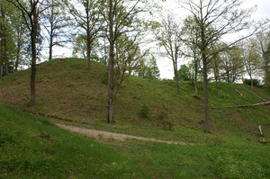
Buses Baznīcas kalns
Buses Church Hill
On the left bank of the Imula River, opposite the Matkule Hill Fort.
The Buses Church Hill is situated about 200 m S of the Buses Hill Fort on the bank of the Imula River. The marked off, roundish hill overgrown by trees rises above the surroundings 6-15 m, it has a plateau of ~ 80 m². Alredy in 1869, researchers, when describing the Church Hill, came to a conclusion that on it there had never been a Christian church and the Church Hill should be considered as an idol`s hill typical of Kurzeme. In later times, there is already news that in the hill or near it they found artefacts. During the archaeological excavation works of 1937, it was established that the top of the Church Hill was covered by a layer of sod with a 10 - 15 cm deep layer of fine limestone and its pieces, under which there was blue fine clay found. These findings along with the animal bones, the Medieval grave of a person, apparently a woman, with a round brooch (sakta) and a coin given along, the significance of the name of the hill and its proximity to the Buses Hill Fort with an ancient town and a burial ground all point at the fact that the Church Hill could be an ancient people`s meeting place and a sacred site.
Dati sagatavoti sadarbībā ar uzziņu portālu www.viss.lv Buses Baznīcas kalns


